


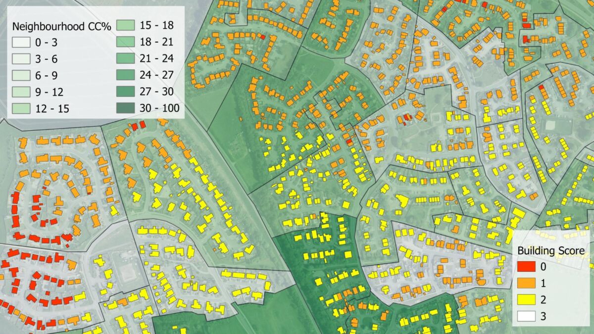
ABERDEENSHIRE Council has collaborated with Bluesky International to assess residents’ access and proximity to trees and green spaces.
The work used a new analysis service that applies the increasingly popular 3+30+300 research rule, which was introduced in 2021 by Cecil Konijnendijk, co-founder of the Nature Based Solutions Institute.
Since gaining traction with urban planners and environmentalists, the method provides a guideline for urban greening, recognising the need for everyone to realise the benefits of living and working within a certain proximity to trees and urban nature.
In simple terms, the rule states that there should be three trees in line of sight, 30% canopy coverage, and green space within 300 metres of all residential and workplace buildings.
The council said it has found the visual representations Bluesky has been able to provide using 3+30+300 analysis and the National Tree MapTM (NTM) data, helped facilitate a wider discussion with local communities about the importance of urban trees, with clear representations of tree and green space locations.
Fiona Chirnside, environmental planner at Aberdeenshire Council, said, “We have applied the analysis from Bluesky, which uses the 3+30+300 rule in conjunction with their NTMTM data, for cross-service discussions specifically for the Inverurie area, as part of the development of a corporate place plan for the settlement.
“Services from across the council, even those who perhaps wouldn’t necessarily see trees or green spaces as part of their remit, can benefit from this information whether it’s for future project planning, resident engagement, or grant applications. We have had interest from colleagues in our roads and education teams and from our health & social care partnership and using the 3+30+300 analysis has meant we can demonstrate the impact location to trees and green spaces can have, especially when we overlay with our social economic data.”
Ralph Coleman, chief commercial officer at Bluesky, added, “When we discovered Cecil Konijnendijk’s research rule, we quickly realised how data from our NTMTM could be used to create an analysis service offering fast and accurate visuals depicting the distances from prescribed residential areas to trees and green spaces. Our NTMTM data is the only comprehensive tree mapping dataset to capture trees three metres and taller across Great Britain and the Republic of Ireland and this has enabled us to be the first to offer national 3+30+300 analysis as a service.
“The outputs, based on existing data sources, are produced rapidly providing local authorities, housing developers and environmental consultants the efficiency required to deliver an effective service.”