

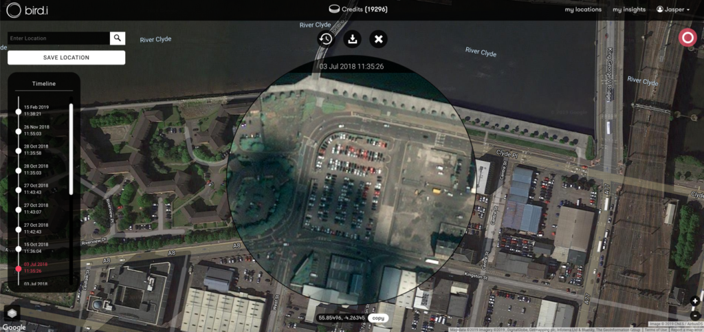
THE Netflix of satellite imagery is how Glasgow-based Bird.i have billed their imagery from space streaming service, which construction companies from around the globe have bought into.
The premise of Bird.i’s service is a platform in which users have access to frequently updated satellite images of every corner of the globe, meaning developments of areas can be tracked via high resolution pictures from above – with users being able to highlight and zoom in on a particular area of land at the cost of a credit, which are purchased using real currency.
“Irrespective of what industry you are in, technology is a means to an end,” said Alan Thompson of Bird.i. “Organisations don’t have to embrace technology; they need to embrace it. We’re trying to produce a technology solution that is available to the mass market – it just so happens that from a construction perspective they are seeing great value in it.”
Founded by French entrepreneur Corentin Guillo, the company set up base in Glasgow because of the talent available in a country expected to have a space industry worth £4 billion by 2030. The service, known as Construction Intelligence, has developed tenfold over the past 18 months, with construction subscriptions from around the world aiding the development of the satellite imagery.
“Our main customers at the moment are either in construction or oil and gas. Essentially, they are interested in seeing things like the construction of pipe lines, or how oil rigs are moving and changing, as well as how construction sites are developing over time – some will be based remotely, and they want to look at construction sites in Dubai, for example,” said Alice Ritchie, marketing manager of Bird.i.
The prospect of not needing to use the more traditional methods in managing the progress of sites is one of the company’s selling points for their service.
“I think from an operational perspective as well we can offer advantages in terms of efficiencies – in terms of people not needing to visit sites anymore, which saves them time and money,” Alice added. “From an operational sense it makes them more efficient, particularly when it comes to international projects. We had a guy who worked for a mining company and his job was to physically go out to different mines and inspect them to see by how much they had expanded or deepened. There were a few places that we showed him on the portal, and he was looking at them and realising that they hadn’t changed that much – meaning he no longer had to make those trips, thus saving the company thousands of pounds.”
The service was recently used by a large hotel chain who wanted to determine whether or not construction had been halted on an area of land which interested them, and they believed could be obtained at a knock down price should the current developer be out of money. Despite having large corporations on board, the service is very much still in development.
Bird.i currently has two customers in particular with a vested interest in construction, however they very much have different wants in terms of what the service does. In one instance, a customer wishes to view several thousand specific locations around the UK in order to track the developments of construction sites, whilst another user has given the company specific coordination’s for land in the Middle East. Despite the two clients using the service for the same end purposes, it is much easier to provide frequently updated imagery for large pieces of land with specific coordination’s, than it is for thousands of specific areas around an entire country – especially when that country presents issues such as frequent cloud cover.
As Jasper Smallenbroek of Bird.i explained, “The update of images depends on the demand for imagery over an area. So, if I own a satellite it costs me to take pictures – because taking pictures drains the battery. I’m not going to be taking pictures all the time, so wherever there is demand they’ll take pictures – so over areas like Dubai there is very high demand for imagery – also the weather is good there so that helps; in Glasgow we can get a good image every couple of weeks or even three months depending on the weather conditions – so really varies.”
They insist that they do not shy away from airing the restrictions of satellite imagery when speaking with potential clients, but also ensure that they are aware of the benefits to the service in terms of keeping track of their site.
“We know what the restrictions are with satellite imagery, but we also know when it can add some real value,” said Alan Thompson. “Once we demonstrate that it’s much more than just an image; it’s how you interpret that image, how you use that image from above for artificial intelligence to produce end results, you see some real value in it.”
In recent years, drones have been a popular means for construction companies to track progress from above, however such a tactic still presents restrictions with no-fly areas, the need for a physical operator of the drone and the inability to check on other construction sites. However, the images are more detailed and close ups of buildings can be taken by drone – which is why Bird.i view their service as one which can work alongside other methods, and in turn provide companies with a full perspective of the progress of their site.
“Satellite imagery removes some of those barriers (presented by drones) – yes the detail might not be as much, but for the purposes of what most of our clients need they don’t need micro analysis, it’s more macro analysis,” Alice Ritchie added. “Such as working out what the progress is, working out if a site is empty, whether a site been demolished or cleared or if construction is complete – rather than how really small sections of a building is progressing. It’s much cheaper as well to use satellite imagery in that context rather than using a drone.
“All these technologies definitely complement each other, and we’re finding more and more companies that we’re speaking to already have their own technology, and they in a way use our data to match up with their methods and it almost enhances both– so it’s very much a complimentary service, you’re never going to find something that overcomes every single restriction.”
Currently, Bird.i technology offers a resolution of one pixel on-screen equalling 30 centimetres on the ground, and any images which feature more than 30% of cloud cover are removed from the algorithm to ensure users are not inundated with images of no use.
Over the next 12-18 months, the company’s primary focus is growing their customer footprint globally and making Bird.i the provider of choice for the latest satellite imagery in construction and other industries.