

A map showcasing the infrastructure works which took place in Glasgow ahead of the recent Commonwealth Games has been launched.
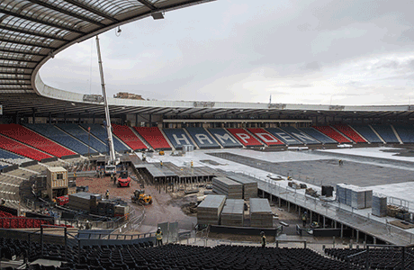
Civil engineering firsts such as the Hampden Park surface raising – which lifted the surface six feet on metal stilts to accommodate the running track and athletics field – are included.
The ‘Engineering the Glasgow 2014 Commonwealth Games’ map will be hosted by Education Scotland on their Game On Scotland website, so primary and secondary school students can learn about the vital role of civil engineers in delivering major sporting events – not just in building or converting the venues, but also ensuring that Glasgow’s water, waste, energy and transport networks were able to accommodate the extra one million visitors.
In order to build the athletics track at Hampden, the competition surface was raised on 6,000 steel posts weighing over 1,000 tonnes and then being covered by a further 16,000 tonnes of stone tar and specialist track material to create a temporary world class track.
The pioneering idea has now become known as “the Glasgow solution” and will allow future track and field events to be hosted on stadia which are not purpose built.
ICE Scotland Director, Sara Thiam, said, “The Games have provided a fantastic showcase of engineering talent in Scotland and we hope the map will be an excellent tool for schools to encourage the next generation of engineers.”
The map also features stories about the creation of new venues such as the Hydro, Emirates Arena and Sir Chris Hoy Veledrome and highlights important civil engineering works such as flooding management and waste treatment.
The map will be available as a teaching resource for primary and secondary schools across Scotland and the UK, as well as being made available to the general public through Visit Scotland, libraries and museums.