

AERIAL mapping company Bluesky has been awarded contracts to map heat loss across towns and cities covering around 10 per cent of the population.
Using specialist thermal sensors mounted on survey aircraft Bluesky records heat loss from homes and businesses.
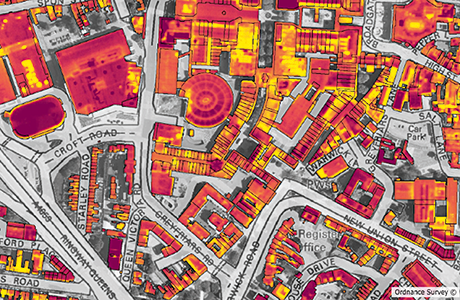
The colour-coded thermal maps are matched against addresses to give accurate and up to date information to tackle fuel poverty, carbon emissions and improve energy efficiency.
Bluesky thermal maps have also been used to identify illegal dwellings and even uncover cannabis factories.
“At a time when energy usage and fuel poverty are again top of the political agenda, it is essential those who are charged with protecting the most vulnerable in society are armed with the information they need,” said Rachel Tidmarsh, Managing Director of Bluesky International. Thermal survey data shows households that differ from adjacent properties. “Most often these are shown as ‘hot spots’ and can be explained by poor insulation however unduly ‘cold’ properties are also of concern as these households may be experiencing fuel poverty where they simply cannot afford to switch on the heating.”